On February 25, the NEOSCC Board voted unanimously to approve and endorse the Vibrant NEO 2040 Vision, Framework and Action Products. We are sharing an “Initiative A Day” so you can gain a better understanding of the vision and framework! If you would like to read all of the Initiatives, you can download them here: Recommendation and Initiatives. You can access a pdf of the entire vision chapter here. The vision chapter contains all 41 initiatives, development strategies, indicators, and matrices that identify how the recommendations, initiatives and indicators all relate.
Show your support for Vibrant NEO 2040 by adding your name to our Champions of Vibrant NEO 2040 list here.
INITIATIVE 7.2: SUPPORT AND EXPAND GREEN INFRASTRUCTURE OPTIONS FOR FLOOD CONTROL AND GENERAL WATER MANAGEMENT, BOTH AT THE LOCAL LEVEL WITH PROJECTS LIKE GREEN ALLEYS AND BIOSWALES, AND AT THE REGIONAL LEVEL WITH A NETWORK OF LARGE, UPSTREAM WATER RETENTION AREAS.

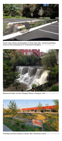
Vacant and abandoned land could provide Northeast Ohio communities with a supply of sites on which to develop green infrastructure. Depending on their scale and position in the watershed, vacant urban lands could be reprogrammed to capture and filter stormwater on site, preventing it from entering streams or pipes in the first instance. Or, such land could be designed to detain stormwater runoff after major events, potentially cleaning and then gradually releasing the water into the stream to alleviate pressure on the system.
WHY THIS IS IMPORTANT. Green infrastructure represents a more cost-effective control method for stormwater that reduces stress on the region’s valuable waterways.
GETTING IT DONE. Local jurisdictions, in cooperation with land banks, should lead the way on introducing green infrastructure to suitable vacant land in downstream communities, as well as using more of porous pavement and implementing bioswale water conveyance treatments.
At a regional scale, Metroparks authorities, land conservancies, and Soil and Water Conservation Districts should collaborate on identifying and developing a network of water retention areas.
POLICY: Adopt a green infrastructure approach to open space, habitat and water resources: The region can benefit in multiple ways by aligning open space, habitat and water resource programs to serve, where effective, as green infrastructure. Green infrastructure allows the integration of inter-related programs such as natural resources management, mapping, parks conservation, floodplain management and planning. It also requires an assessment of the full range of economic value and costs related to land conservation.
BEST PRACTICE: Combined Sewer Overflow mitigation —The Northeast Ohio Regional Sewer District plans to spend $42 million over the next several years on neighborhood “green infrastructure” projects aimed at reducing flooding and the discharge of untreated waste.
PILOT PROJECT: Green Street Project: Project that aims to beautify residential neighborhoods while reducing run-off from storm water; program also incentivizes residents to utilize sustainable solutions as residents who adapt the practices receive a discount on their NEORSD stormwater utility fee.
| Lead | Metroparks Authorities, Land Conservancies and Trusts; Municipalities, Townships, Counties; Soil and Water Conservation Districts |
| Target Community | Strategic investment areas, asset risk areas, cost risk areas |
| Implementation Complexity | Moderate |
These recommendations, initiatives, and products, are not one-size-fits all and some aspects of the initiatives won’t be applicable everywhere in the 12-county region. The Vibrant NEO 2040 Vision, Framework and Products are intended inspire and guide decision-making at the Metropolitan Planning Organization (MPO), Council of Government, and local levels to ensure that land use, transportation, and environmental considerations are simultaneously addressed by their processes. Ultimately, the implementation of Vibrant NEO 2040 is up to Northeast Ohio’s communities and residents. But regardless of the applicability of each initiative to any particular part of the region, the goal for each community within the Vision is the same: stability, prosperity, and a high quality of life for all of its residents.
